
Last modified: 2025-06-27 by daniel rentería
Keywords: culiacan | sinaloa | aguaruto | costa rica | tahuichamona | bandera municipal y escudo municipal (sinaloa) | escudo del municipio (sinaloa) | bandera del municipio (sinaloa) | héraldica municipal de sinaloa |
Links: FOTW homepage |
search |
disclaimer and copyright |
write us |
mirrors
See also:
I contacted the municipality, and they informed me they do not use a municipal flag.
Daniel Rentería, 9 May 2025
.gif)
image from culiacan.gob.mx
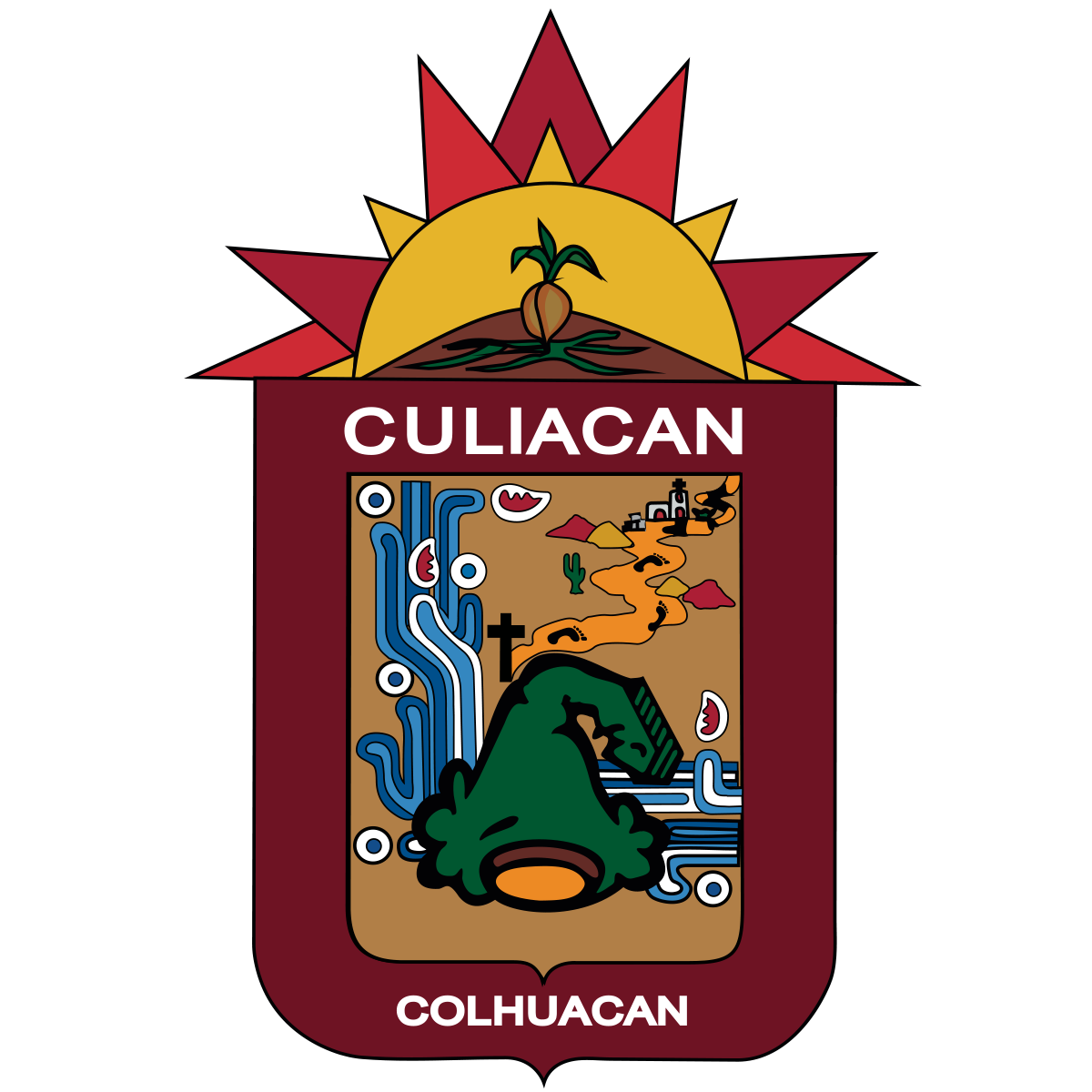
The coat of arms of Culiacán was designed by Rolando Arjóna Amabilis and adopted through Municipal Decree N°13 on 25 May 1960, published in the State Newspaper on 30 July 1960. A translation of the decree is provided:
FIRST ARTICLE. It is declared as the Official Coat of Arms of Culiacán, the project of the same...and is of quadrilong form with rounded edges, finishing in a point. All of the "field" of the shield is covered in a reddish color of land, a hieroglyph occupies it representing a hill with a human head on top, very inclined towards the front and alludes to Coltzin, "The Crooked God", authentic figure in Nahuatl mythology, who gave name to a Nahuatl-Colhua tribe and this, to the time, their town of residence, Colhuacán or Teocolhuacán.
Behind the hieroglyph to the right appears symbols of water, making reference to the rivers: over the same hieroglyph, in the central part and to the left side, appears a cross followed by a path over it from which footprints of feet are observed [plus hills and a cactus to the side for the environment], that of which ends in a small construction [a mission], motives which symbolize the missionaries of San Miguel de Culiacán that parted towards the north and invoke them as an obligated homage bonding and heroism of the missionaries.
Over the bordure of carmine color, it is read in its upper part the word "Culiacán", and in its lower part the word "Colhuacán", which corresponds to the true name of the place in Nahuatl. In the upper part of the shield a hill with a seed in germination is situated, and over the same, the figure of a sun in gold which alludes greatly to the tropical climate of this region like to that of effort fundamentally agricultural of its inhabitants.
Daniel Rentería, 13 April 2025
.gif)
image from Facebook
The coat of arms of Aguaruto was designed in 1994, divided into four quadrants. Its border is white and reads at the top AGUARUTO and AHUASUTO at the bottom, its original name. Another border is placed on top of this, and is filled with footprints; at the top on each corner is a flower. Description according to archive.org for the quadrants:
The first presents the arrival of some families originating from the settlement existing in Culiacancito which is manifested through some feet that cross the Culiacan River [with mountains in the distance].
The second in the lower part indicates the arrival of some indigenous families which found a place full of bushes denominated GATO [cat] which possesses some spikes in the form of the nail of a cat, for which they named htis place "Aguasuto" in the CAITA [cahita] dialect which wants to say Nail of Cat, later on it transformed into Aguaruto.
The third quadrant, situated in the upper-right part is the Mexican Railroad or Tacuarinero, Culiacán, Altata, likewise its principal fruit products and the arrival in 1970 of the first preparatory school which was founded outside of our capital city.
The fourth and last represents the agricultural and technological advance, but above all, which specifically in Moroleón was sown for the first time in 1937 the fat tomato of exportation from which the nickname of tomato growers of Culiacán was received.
Daniel Rentería, 13 April 2025
.gif)
image from Facebook
The coat of arms of Costa Rica was designed by the plastic artist Rubén Pérez León with the help of historians Francisco Soto Leyva, Guillermo Valdez Fuentes, Benjamín Luna Lujano, and Jesús Alberto Morales in 1999. It depicts as its bordure the form of an eagle for the Nationality, at the top SINDICATURA DE, and at the bottom a ribbon reading COSTA RICA. The inner section is divided diagonally into four quadrants. At the top is a sugar mill, a principal source of work in the community. To the left, two bags, tomatoes, and a corn plant for agriculture. To the right, a locomotive on train tracks and a map of the state with Culiacán Municipality highlighted, having footprints over this and the train tracks; these are the ways the first settlers got here, railway and by foot. At the bottom is an image of the sun rising over hills and the valley, an image of the environment; below is the motto TIERRA RICA Y FÉRTIL [Rich and Fertile Land].
Daniel Rentería, 13 April 2025
.gif)
image from Facebook
The bordure carries the name TAHUICHAMONA and CAHITA-NAHUATL, the group that lived in the area. 1981, when it became a syndicate, is found at the bottom, with footprints on the sides for the Indians that made pilgrimates through here. To the sides are colorful lances likely for culture and sugarcane plants as a well-known product of the Valley. As for the inner section, at the top the local Saint Francis of Assisi church is seen with a background of hills. To the lower-left is a hand spreading seed among the valley, with three plants visible and a deer for fauna, with hills as the background. To the lower-right, two masks are seen for Indian traditions, a parrot and macaw also for fauna, hill for the mountains nearby, and circular building probably representing the town center, existing before the Spanish colonial era. In the center is a petroglyph, reminiscent of the petroglyphs found at the foot of the Chivos Hill.
Daniel Rentería, 13 April 2025
Anything below this line was not added by the editor of this page.