
Last modified: 2020-02-26 by rob raeside
Keywords: kamchatka | volcano | mountains: 3 | fire | waves: 3 |
Links: FOTW homepage |
search |
disclaimer and copyright |
write us |
mirrors
 from Territorial website, 17 Feb 2010
Kamchatka Kray was formed on 1st Jul 2007 from a merger of the former Kamchatka oblast and the Koryak Autonomous Okrug.
(Note: You need an Unicode-aware software and font to correctly view the Cyrillic text on this page. See here transliteration details).
February 17 2010, at the session of the Legislative Assembly of Kamchatka Krai adopted laws on national emblem, flag and anthem of the Kamchatka region.
Projects of official symbols were developed in the framework of a competition announced by the Government of the Kamchatka Territory, which was attended not only to Kamchatka, but also representatives of other regions. Heraldry Commission has recognized the best projects of the emblem and flag of Ivan Tsar'kova, sponsored hymn are Honored Artist of Russia, the artistic director of the Kamchatka Choir Evgeny Morozov and poet Boris Dubrovin.
The emblem of the Kamchatka region shows three of the volcano with snow-capped peaks and rising because of the volcano sun, framed by a national ornament. The lower part of the shield is blue separated by a wavy line symbolizing the Pacific Ocean and the seas surrounding Kamchatka.
Flag of Kamchatka Territory is a rectangular flag divided horizontally on the bottom of the blue and the upper part white, which is placed the emblem of the Kamchatka region.
Officially, the new symbols will be used from July 1, 2010 - the third anniversary of the formation of the new RF subject that united the Kamchatka Oblast and Koryak Autonomous Area. Told a "PC" the press service of the Governor and the Government of the Kamchatka region.
Source: http://www.poluostrov-kamchatka.ru/index_1.shtml?2010/100218/03.txt
Mikhail Revnivtsev posted on RossoVex-ml, 19 Feb 2010
kamch.gif) from Territorial website, 17 Feb 2010
from Territorial website, 17 Feb 2010
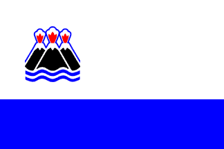 image by António Martins, 18 Nov 2005
On a page at
the
website of local newspaper Vesti, I think that this is the winning
design of the arms of Kamchatka which are displayed there in black and white.
They talk about the final adoption of the flag and arms of Kamchatka in
February 2002. The flag should be blue and white with the arms on it.
Pascal Gross, 08 Feb 2002
At
the
official Russian symbols website we learn that the regional flag of
Kamchatka is indeed blue and white, horizontally set with the blue are half
the white and an emblem on the upper hoist and 2:3 ratio,
which was adopted on April 15th, 2004.
António Martins, 18 Nov 2005
f.gif) image by António Martins, 18 Nov 2005
image by António Martins, 18 Nov 2005
The emblem is a modification of the arms. The version shown in the
mentioned page seems to be itself a stylization or simplification of the
1913 (and previous) arms, which are much more like what’s common in
recent Russian subnational Heraldry.
António Martins, 18 Nov 2005
 image by António Martins, 18 Feb 1999
This is the flag of the old Kamchatka free
state (cf. Adolfo Duran via Michel Lupin via Falko Schmidt).
According to SAVA newsletter 24
[sav], via Falko Schmidt, the flag is in use
today.
Dirk Schönberger, 15 May 2000
Here «in use» may mean official use or not (I guess not), and it is
not clear by whom it is used. Also «today» refers to the date of SAVA
newsletter 24 (which was…?).
António Martins, 17 May 2000
 image by
Tomislav Šipek, 3 January 2020
image by
Tomislav Šipek, 3 January 2020The new flag of the city is a banner of
arms.
http://test.ia41.ru/v-den-flaga-12-yunyh-zhitelej-petropavlovska-poluchili-pasporta/
https://pressa41.ru/sport/lady-emma/
Tomislav Šipek, 3 January 2020
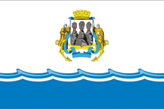 image by
Tomislav Šipek, 3 January 2020
image by
Tomislav Šipek, 3 January 2020Flag of city of Petropavlovsk-Kamchatsky in Kamchatka Territory is adopted in 18-oct-2006. Flag is divided by wavy line (symbolizing seaport) in two fields: upper - white and bottom - light blue. Height ratio of fields is 2:1. Ratio of the flag is 2:3. White filed is charged with city's coat of arms. Shield is Argent with three active volcano peaks.
Image according to city assembly web site:
http://dumapk.ru/simvol.html
Ivan Sarajcic, 30 Apr 2009
 Chrystian Kretowicz, 7 May 2009
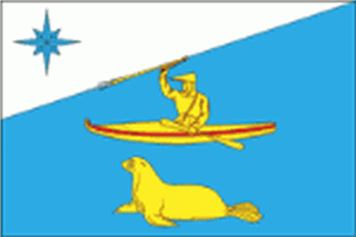
The administrative center (and only village) is Nikolskoye (Никольское)
Municipal District of the Kamchatka Region (until July 1, 2007 - Kamchatka Oblast'). Occupies the territory of the Commander Islands (Командoрские острова) - Bering Island (остров Беринга), Mednyi Island (Остров Медный) and 15 smaller ones. Most of the inhabitants are of mixed, Aleut, Russian, Koryak and Ainu origin, although there some real Aleuts and Russians among them. Vitus Bering, who discovered the islands, died there in 1741. There is a booklet describing the islands in considerable detail at: http://www.bering.narod.ru/eng/booklet.htm>
The flag described as: blue in the ratio 2:3 with the white ascending triangular wedge at the upper edge and figures from the emblem in colors of yellow, red, white and blue. Symbolism: The colors and figures mirror the national, ethnographic and economic peculiarities of the Aleutian homeland. The hunter in native clothing seats in the kayak and holds a local hunting gun, sort of harpoon with three additional arrows. This image stresses the hardship conditions of making a living in the Far East. There is also an image of the sea lion, symbol of the local fauna and wealth. On the white edge, there is a blue compass rose (Rose of the Winds) - symbol of discoverers, travelers and mariners. Commander Islands are often called :"The Land of Winds and Storms".
The blue color (lazure) is a symbol of high aspirations, sincerity, loyalty
and revival.
The white (silver) color is a symbol of purity, openness, divine wisdom
and reconciliation.
The yellow (gold color) stands for supreme values, greatness, generosity,
wealth and the crops.
The red color signifies the character, work, courage, contest and holiday.
Allegorically, it represents the workers of the Commander Islands.
The authors of the emblem and flag are: Konstantin Mochenov (of Khimki) - Chief of the Project Oksana Afanasyeva (of Moscow) - artist and digital designer Vyacheslav Mishin (of Khimki) - symbolism
The Emblem and the Flag were adopted by the resolution of the local Duma (Parliament) # 163 dated December 1, 2008.
The description is available at http://geraldika.ru/symbols/22588
and at http://www.heraldik.ru/flags/aleutskiymr_f.htm where the first image
of the flag appeared today. (all in Russian)
Chrystian Kretowicz, 7 May 2009