
Last modified: 2021-08-26 by  klaus-michael schneider
Keywords: lara | torres | carora |
Links: FOTW homepage |
search |
disclaimer and copyright |
write us |
mirrors
 (2:3)
(2:3)
by Pascal Gross, 16 November 2001
See also:
At <www.encarora.com/datos.htm>
we can see the flag and Coat of Arms of Torres Municipality
(capital: Carora), but, unfortunately, there's no backgrounds
information about the flag.
Pascal Gross, 16 November 2001
The municipality of Torres (1,185,014 inhabitants in 2005, including 192,599
inh. in the town of Carora proper; 7,437 sq. km, that is nearly half of the area
of the Lara State) is located on the borders with the Falcón, Trujillo and Zulia
States.
Carora was established in 1569 by Juan del Thejo. Originally named Nuestra
Senora de la Madre de Dios de Carora, the town was transferred on 6 January 1571
to its present-day site by Juan de Salamanca. It is believed that the town was
relocated because of the threat caused by the Axaguas and Jirajaras natives.
Juan de Salamanca set up an official administration and renamed the town San
Juan Bautista de Portillo de Carora. The name of Portillo refers either to
"gate" in the western mountains heading to Zulia or to the Spanish region where
the re-founder originated.
Carora was renamed Torres on 9 September 1881 by the Constituent Assembly of the
Lara State. The municipality is named for Pedro León de la Trinidad de la Torre
y Arrieche (1788-1822), born in Arenales, joined in 1810 the independentist
troops commanded by Francisco de Miranda; appointed in 1822 Chief of the South
Army, Torres died after having been injured during the Battle of Bomboná.
Source:
http://www.encarora.com/Resena.htm
Ivan Sache, 17 July 2013
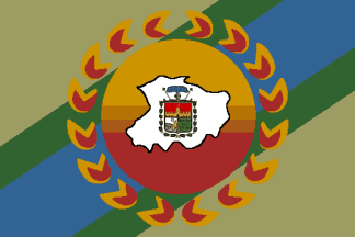
The flag of Torres, deigned by Juan Carlos Roche Pire, is prescribed by
Municipal Decree No. 17 of 4 February 2000.
The flag was selected in a public contest, which yielded 31 proposals. The jury
addressed the following items;
- Link with the municipal arms;
- Link with the parishes;
- Explanation and meaning of the proposed design;
- Colour combination and aesthetics;
- General appearance;
- Compliance with the contest's rules;
- Individual evaluation by the jury's member;
- Collective evaluation by the jury.
The proposal that got the best evaluation was officially presented in a public,
solemn ceremony held on 12 March 2000 (National Flag's Day) on Plaza Bolívar.
The diagonal blue stripe represents the watercourses of the municipality and the
sky that hoists the sun at sunset. The diagonal green stripes represents
agriculture and cattle-breeding, the main sources of income for the
municipality, managed along the watercourses.
The central ochre disc is a graphical representation of sunset and of the
dryness of the region. The 17 flames surrounding the central disk represent the
17 parishes* forming the municipality. The flames also represent the sun
rays and high temperature (the yearly average temperature is 28°C); they also
recall the local legends featuring the Carora Devil. The map and the coat of
arms of the municipality are placed in the middle of the flag. The colours
(blue, green, orange, yellow, white and silver) are those of the coat of arms.
Source:
http://www.encarora.com/Bandera%20de%20Torres.htm
Ivan Sache, 17 July 2013
The 17 parishes are (capital between brackets):
Trinidad Samuel (Carora)
Montes de Oca (San Francisco)
Camacaro (Río Tocuyo)
Antonio Díaz (Curarigua)
Manuel Morillo (El Empedrado)
Castaneda (Atarigua)
Chiquinquirá (Aregue)
Espinoza de Los Monteros (Arenales)
Torres (Jabón)
Lara (San Pedro)
Montanas Verdes (Palmarito)
El Blanco (Quebrada Arriba)
Cecílio Zubillaga (La Pastora)
Las Mercedes (Burere)
Reyes Vargas (Parapara)
Heriberto Arroyo (El Paradero)
Altagracia (Altagracia)
Ivan Sache, 17 July 2013