
Last modified: 2024-05-12 by rick wyatt
Keywords: prince george's county | maryland |
Links: FOTW homepage |
search |
disclaimer and copyright |
write us |
mirrors
![[Flag of Prince George's County]](../images/u/us-md-pg.gif) image by Pascal Gross, 23 December 1998
image by Pascal Gross, 23 December 1998
![]() - indicates flag is known.
- indicates flag is known.
![]() - indicates it is reported that there is no known flag.
- indicates it is reported that there is no known flag.
Municipal flags in Prince George's County:
See also:
The simple, yet distinctive Prince George's County flag is a fascinating blend of history and heraldry dating back to the 11th century. Soon after the county's founding, it was granted colors for horses and foot soldiers and a flag consisting of St. George's Cross on a white field. The red cross of St. George has a long standing tradition of its own as the symbol of Christian martyrdom since its first use during the great Crusades.
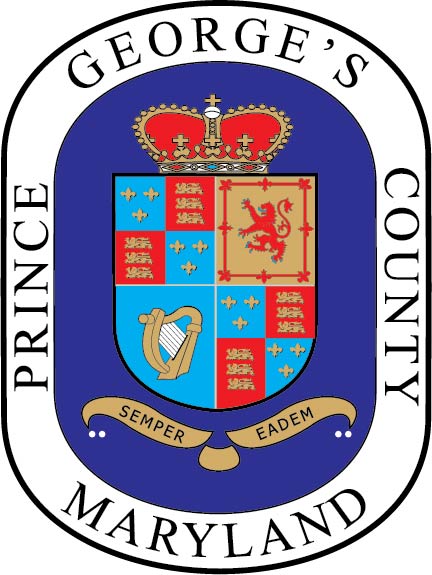
The county seal in the flag's upper left quadrant did not official become a part of the flag until 1963. At that time, a special committee suggested that the seal be added to "more definitely establish the colors as uniquely those of Prince George's County." The seal was designed in 1696 by Charles Beckwith of Patuxent. The coat of arms in four quarters symbolizes Queen Anne, France and England in the first and fourth grand quarters; Scotland in the second grand quarter; and Ireland in the third. The banner below depicts the county motto, "Semper Eadem," which means "Ever the Same."
Source: www.co.pg.md.us/About/facts_history.asp?nivel=subfoldmenu(0,1)
Phillip L. Nelson, 29 June 1998
Prince George's County (801,515 inhabitants in 2000; 129,000 ha; seat, Upper Marlboro), located close to Washington, D.C., was named for Prince George of Denmark (1653-1708), the husband of Anne (1665-1714), Queen of Great Britain (1702-1714). Created by the Council of Maryland in 1695 from portions of Charles and Calvert Counties, Prince George's County was detached a portion in 1748 to form Frederick County, subsequently divided into Allegany, Garrett, Montgomery, and Washington Counties.
The county seal, which is placed in the canton of the flag, is described on the website of the National Association of Counties as follows:
"Prince George's County was created from Calvert County and Charles County in 1695. The county was named for Prince George of Denmark, husband of the heir to the throne of England, Princess Anne. Charles Beckwith of Patuxent designed the Prince George's County seal in 1696.
![[Flag of Prince George's County, Maryland]](../images/u/us-md-pg_so.gif) image by D.M.S., 24 August 2017
image by D.M.S., 24 August 2017
![[seal of Prince George's County, Maryland]](../images/u/us-md-pg).gif) image located by Paul Bassinson, 8 July 2018
image located by Paul Bassinson, 8 July 2018
Image obtained from
my.solarroadmap.com
Paul Bassinson, 8 July 2018