
Last modified: 2018-12-15 by rob raeside
Keywords: roerdalen |
Links: FOTW homepage |
search |
disclaimer and copyright |
write us |
mirrors
 Shipmate Flagchart : http://www.flagchart.net
adopted 1 Jan 1991 design: Stichting voor Banistiek en Heraldiek
![[Roerdalen Coat of Arms]](../images/n/nl-li)rd.jpg) from the Roerdalen municipal site.
from the Roerdalen municipal site.
Granted 21 Aug 1991; the left part with the double-tailed lion is from Melick en Herkenbosch; the right part from Vlodrop.
![[Melick en Herkenbosch flag]](../images/n/nl-li_mh.gif) by Jarig Bakker, 3 Nov 2003
by Jarig Bakker, 3 Nov 2003
The former municipality of Melick and Herkenbosch counted 5.000 inhabitants,
along the German border, consisting of the settlements Melick (seat), Herkenbosch,
and Meinweg. In Melick is the farm Schöndeln, formerly the castle
of the Counts of Gulik. The municipality used to be part of that county;
in 1816 it was assigned to the Netherlands.
Flag: wavy vertically divided of red and white, with in the center
two arrows in the form of a St. Andrew's cross, countercharged.
Date of adoption unknown.
The waves refer to the Roer river, which separates Melick en Herkenbosch
from Vlodrop.
Source: Derkwillem Visser's "Gemeentewapens en vlaggen Koninkrijk
der Nederlanden", 2001.
Jarig Bakker, 3 Nov 2003
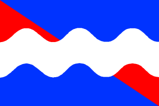
![[Vlodrop flag]](../images/n/nl-li_vd.gif) by Jarig Bakker, 3 Nov 2003
by Jarig Bakker, 3 Nov 2003
The former municipality of Vlodrop counted 2.250 inhabitants along the
Roer river and the German border. Settlements: Vlodrop (seat), Etsberg,
Rothenbach, Tusschen de Bruggen, and Vlodrop-Station. On its territory
was the unfinished Statemine Beatrix.
Flag: diagonally divided of yellow and blue, with on the diagonal a
red stripe of 1/5 flagheight, on which a wavy white stripe of 1/20 flagheight
and at least four waves.
Adopted 17 Mar 1983 by municipal resolution.
The wave represents the Roer river, which separated Vlodrop from Melick
and Herkenbosch.
Source: Derkwillem Visser's "Gemeentewapens en vlaggen Koninkrijk
der Nederlanden", 2001.
Jarig Bakker, 3 Nov 2003