by Jens Pattke, 21 December 2004

Last modified: 2024-04-27 by daniel rentería
Keywords: cundinamarca | zipaquira | sabana centro |
Links: FOTW homepage |
search |
disclaimer and copyright |
write us |
mirrors

by Jens Pattke, 21 December 2004
See also:
According to <www.geocities.com/zipaquira2000>
, the flag is charged with
the coat of arms.
Dov Gutterman, 15 April 2004
From <www.cundinamarca.gov.co>:
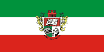
"Pabellón con franjas iguales en forma horizontal, con los
siguientes colores:
Verde, simboliza la riqueza del suelo y la fertilidad de la
sabana.
Blanco, pureza y la calidad de ciudad Real de la Villa.
Rojo, la sangre de los mártires y patriotas por conseguir la
libertad. En el centro del pabellón se encuentra estampado el
escudo del municipio."
Felipe Carrillo, 20 November 2004
Flag adopted officially by Municipal Resolution No. 7 of August 27 1981.
Translated, the description of the flag goes as follows: "Flag with equal stripes in horizontal form, with the following colors:
Green: symbolizes the richness of the soil and fertility of the savanna.
White: symbolizes purity and the quality of the royal city.
Red: symbolizes the blood of the martyrs of Zipaquirá in the struggle for liberty and of the patriots in giving liberty. Pressed in the center of the flag is the coat of arms of the municipality."
You can also listen to the anthem and see the legislation on the symbols on a local museum's website, here at https://museodezipaquira.com/generalidades/
Daniel Rentería, 10 October 2023

by Pascal Gross, 26 October 2000
cunzi.jpg)
from <www.cundinamarca.gov.co>
Coat of arms adopted officially by Municipal Resolution No. 3 of August 27 1981. The coat of arms was designed by Colombian heraldist Enrique Ortega Ricaurte and presented to the municipal council in 1954, however not adopted until very long after. It is a modification of the original coat of arms.
The upper half of the shield contains an open book, the left page reads, translated, "CAPITULATION OF THE COMUNEROS", above it being a royal crown, symbol of the Spanish monarchy who the comuneros and afterwards the martyrs of Zipaquirá fought against. The right page, translated, contains the words "Zipaquirá June 08 of 1781". Above is a Phrygian cap, symbol of the liberty obtained in the year 1810. It sits on a red background, symbol of love and sacrifice to the nation.
The lower left's background is a sky blue background. A mountain is depicted, symbol of richness in salt. The community is also shown with a walled enclosure, signifying the big city over grooves with richness in the agriculture of the land.
On the lower right is a sky blue background. The facade of the Cathedral of Zipaquirá and a miter above is shown. These are symbols of the Catholic religion which is professed by residents; also displaying the quality of the Episcopal seat, and the richness of the architecture imposed on the city. It pays tribute to Fray Domingo Petrez, author of the plans of the building.
The coat of arms is crowned by a castellated tower, symbolizing the quality of the community and demonstrates the three titles of the city: very strong, very loyal, and very noble.
Below the coat of arms is the motto of the city, translated, "All for the Nation", which was demonstrated when the city gave up its product, salt, in favor of independence. On the sides of the coat of arms are vegetable leaves, styled in yellow and green, characteristic of the Spanish nobility.
cunzi2.jpg)
from <https://centrodehistoriazipaquira.blogspot.com/2016/03/el-primer-escudo-de-zipaquira.html>
The municipality did have a former coat of arms. This coat of arms was designed by Councilor Dr. Cárdenas Rojas who sparked interest in the concept. Salvador Romero drew the first copy of the coat of arms. It was adopted in 1948 and used until the adoption of the current one in 1981. It depicts the stages of the city in its images and at the bottom displays the area's salt flats on a map of Colombia.