
Last modified: 2024-02-10 by martin karner
Keywords: @ |
Links: FOTW homepage |
search |
disclaimer and copyright |
write us |
mirrors
|
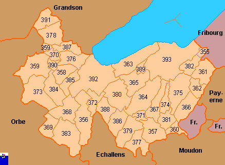
355 Arrissoules 356 Belmont-sur-Yverdon 357 Bioley-Magnoux 358 Chamblon 359 Champvent 360 Chanéaz 361 Chavannes-le-Chêne 362 Chêne-Pâquier 363 Cheseaux-Noréaz |
364 Cronay 365 Cuarny 366 Démoret 367 Donneloye 368 Ependes 369 Essert-Pittet 370 Essert-sous-Champvent 371 Gossens 372 Gressy 373 Mathod |
374 Mézery-près-Donneloye 375 Molondin 376 Montagny-près-Yverdon 377 Oppens 378 Orges 379 Orzens 380 Pomy 381 Prahins 382 Rovray 383 Suchy |
384 Suscévaz 385 Treycovagnes 386 Ursins 387 Valeyres-sous-Montagny 388 Valeyres-sous-Ursins 389 Villars-Epeney 390 Villars-sous-Champvent 391 Vugelles-la-Mothe 392 Yverdon-les-Bains 393 Yvonand |
Copyright: FOTW Yverdon map by António Martins and boundaries’ data by Jarig Bakker. If you wish to reuse them on your website, read our copyright rules.