
Last modified: 2020-07-18 by ian macdonald
Keywords: rio grande do sul | esteio |
Links: FOTW homepage |
search |
disclaimer and copyright |
write us |
mirrors
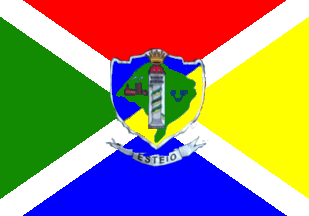 image by
Ivan Sache, 17 July 2020
image by
Ivan Sache, 17 July 2020
The municipality of Esteio (80,669 inhabitants in 2010; 27.5 sq. km) is located in the Porto Alegre Metropolitan Area, 20 km of Porto Alegre. Esteio emerged during the building of the railway line in the Porto Alegre Metropolitan Area. In 1873, the newly built Porto Alegre - Novo Hamburgo railway divided the Areião do Meio estate, owned by the Baroness of Gravataí, into two parts. The small village that formed there became the 7th district of the municipality of Sapucaia do Sul. Inaugurated in 1905, the railway station boosted the settlement of the area. In 1930, the engineer Ildo Meneghetti and Osvaldo Kroeff founded the "Cia Geral de Obras de Esteio Ltda.", which sold plots of land in the area; Kroeff's personal plots were located between the railway station and the Bells' River, today the Assis Brasil Exhibition Park. The urbanization of Esteio was increased by the building of the State road Porto Alegre-São Leopoldo.
Ivan Sache, 20 March 2012
The flag of Esteio is prescribed by Municipal Law No. 832 promulgated on 3
May 1973.
Article 1.
The flag is composed of a rectangular panel,
divided into four isosceles triangles with the vertices in the flag's center and
the bases along the edges, separated from each other by a white stripe. The
upper triangle is red, the left yellow, while the coat of arms is placed over
the junction of the triangle's vertices.
a) The coat of arms is composed
of a panel with three sides, the two lateral formed of mixed, rectilinear and
parallel in the upper third and divergent arches, concave and convex, connected
by an obtuse angle in the lower end, and the upper formed of a broken line of
three sections, the central place above the two lateral, with rounded borders.
The panel divided into two parts by a rectilinear diagonal line running from the
upper right corner and reaching the border at the arches' junction, forming two
opposite fields, the upper left celestial blue and the lower right golden
yellow. the panel charged with a sea green map of Rio Grande do Sul running
close to its borders. In the center of the vertical dimension, a white rectangle
charged with a light grey stele-column with three superimposed capitals,
touching the ends and wrapped by a green-yellow stripe inscribed "28 de Fevreiro
1955"; in the left part a scarlet industrial complex and in the right part a
celestial blue winged circle in the rectangle's upper part at the scarlet
cogwheel's midpoint. The shield surmounted by a golden yellow mural crown.
https://leismunicipais.com.br/a/rs/e/esteio/lei-ordinaria/1973/84/831/lei-ordinaria-n-831-1973-adota-e-define-a-bandeira-do-municipio
Leis Municipais database
The flag was amended by Municipal Law No.
831 promulgated on 13 February 2008.
Article 1.
Item b) shall be added
to Article 1. of the Municipal Law No. 832 promulgated on 3 May 1973, as
follows:
b) Beneath the shield a scroll with the name "Esteio".
https://leismunicipais.com.br/a/rs/e/esteio/lei-ordinaria/2008/453/4536/lei-ordinaria-n-4536-2008-altera-a-lei-municipal-n-831-73-que-adota-e-define-a-bandeira-do-municipio
Leis Municipais database
On the flag in actual use, the coat of arms
differs from the self-standing version used on official documents by having a
thin white outline and the crown not overlapping out of the shield.
Photo
http://www.lasalle.edu.br/esteio/sobre-o-colegio/noticia-detalhe/18795
Ivan Sache, 17 July 2020