
Last modified: 2020-07-14 by ian macdonald
Keywords: rio grande do sul | coronel barros |
Links: FOTW homepage |
search |
disclaimer and copyright |
write us |
mirrors
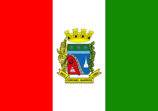 image by Ivan Sache,
14 July 2020
image by Ivan Sache,
14 July 2020
The municipality of Coronel Barros (2,460 inhabitants in 2011; 16,295 ha) is
located 410 km north-west of Porto Alegre.
Coronel Barros was established
in 1915 by the Freüdenberg, Krombauer and Wünsch families, coming from Old
Colonies in Venâncio Aires and Estrela. Petre Krombauer set up in 1916 a
sawmill.
The district of Coronel Barros was established within Ijuí on 22
January 1956. The municipality of Coronel Barros was established by State Law
No. 9,575 promulgated on 20 March 1992.
https://www.coronelbarros.rs.gov.br/
Municipal website
Ivan Sache, 14 July 2020
The flag of Coronel Barros is prescribed by Municipal Law No. 15 promulgated on
3 March 1993.
Article 1.
A flag divided into three vertical rectangles
in colors red (left rectangle), white with the municipal coat of arms in the
center, and green (right rectangle).
The colors featured on the municipal
flag symbolize the colors of the national flag and of the Rio Grande do Sul flag
and contains the coat of arms of the municipality of Coronel Barros.
https://leismunicipais.com.br/a/rs/c/coronel-barros/lei-ordinaria/1993/2/15/lei-ordinaria-n-15-1993-adota-a-bandeira-do-municipio-e-da-outras-providencias
Leis Municipais database
The coat of arms of Coronel Barros is prescribed
by Municipal Law No. 13 promulgated on 3 March 1993.
Article 1.
A
shield divided in three parts; in chief, on a field vert (green), three stars
whose color argent (silver) symbolizes Colonel Barros' rank; dexter, on a field
gules (red) tools symbolizing the development of arable land and the
mineralization of basaltic rock; sinister, on a field azure (blue), a white
church; a river azure (blue) and road BR285 argent (silver) dividing the shield
per bend. The shield surrounded on its two sides by soybean and wheat plants.
The shield surmounted by a four-towered mural crown or, meaning the sovereignty
of a town that has to defend itself. Beneath the shield a scroll inscribed sable
(black) "20/3 - CORONEL BARROS - 1992".
https://leismunicipais.com.br/a/rs/c/coronel-barros/lei-ordinaria/1993/2/13/lei-ordinaria-n-13-1993-institui-o-brasao-do-municipio-de-coronel-barros-e-da-outras-providencias
Leis Municipais database
Photos
https://www.facebook.com/pmcelbarrosoficial
https://www.facebook.com/pmcelbarrosoficial
https://www.facebook.com/pmcelbarrosoficial
Road BR285 (675 km), with
ends in Araranguá (Santa Catarina) and Săo Borje (border with Argentina) crosses
Rio Grande do Sul from east to west, serving the towns of Vacaria, Passo Fundo,
Carazinho and Ijuí.
Ivan Sache,
14 July 2020