
Last modified: 2024-09-14 by daniel rentería
Keywords: mexico | baja california sur | mulege | baja california | cortés sea | california | sudcaliforniano | cachano |
Links: FOTW homepage |
search |
disclaimer and copyright |
write us |
mirrors
By Daniel Rentería from emblem on the
Mulegé government site, 13 September 2024
1 |
mulege.gob.mx
See also:
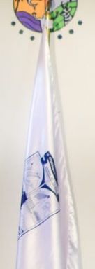
The flag of Mulegé, never adopted by official means, consists of a white field with its coat of arms,in blue and white,
centered upon it. I was informed that this flag was adopted in 2021, at the start of the tenure of Mayor Edith Aguilar Villavicencio.
Daniel Rentería, 13 September 2024
.gif)
image from Facebook
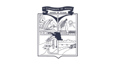
The coat of arms of Mulegé was adopted in January of 1973, just a year after becoming a municipality, and designed by Lorenzo Beltrán Ruiz of Santa Rosalía. It was adopted after a contest launched by the Municipal Council, presided over by Juventino Hernández Rubino, the first municipal president. Information thankfully received from the Social Communication Director of Mulegé. Description of the coat of arms, according to the National Encyclopedia of Municipalities and Delegations:
Crowning the coat of arms, a type of waving ribbon is found, where it reads H. Ayuntamiento de Mulegé [Honorable Council of Mulegé], to observe a vertical rectangle below it, where in its lower point it carries the classic allegory of a spearhead, evoking its historic past. On the border of the upper left, mountain ranges and fishing in the Pacific North zone are symbolized; in the background, the Mission of San Ignacio and its production of dates is highlighted. As a symbol of accelerated progress which was marked on the region in the '70s, maritime communication is shown in a beautiful perspective, represented by a ferry and a stretch of the transpeninsular highway.
In the upper right section, the transformation of the desert is expressed in the conversion to an agricultural center of first order, thanks to the tenacity and effort of the man who loves the land. In the center of the rectangle divided into four parts, the color red on the map of the municipality is observed. In the lower left section, mining activity is represented, which for one hundred years was the economic bastion of life in the region, reflected by the forge of copper, the chimneys, and a pickaxe and shovel, which crossed together represent the permanent unity of man and rudimentary work. In the last of the sections, the lower right, the enormous deposits of salt in Guerrero Negro and exploitation of gypsum on the Island of San Marcos are represented.
Daniel Rentería, 13 September 2024
Anything below this line was not added by the editor of this page.