image by Ivan Sache, 10 May 2015

Last modified: 2021-08-25 by rob raeside
Keywords: jerez | jutiapa |
Links: FOTW homepage |
search |
disclaimer and copyright |
write us |
mirrors

image by Ivan Sache, 10 May 2015
See also:
The municipality of Jerez (9,845 inhabitants in 2009) is located in the
south-east of Guatemala, on the border with El Salvador, 50 km of Jiutapa and
200 km of Guatemala City. The municipality was originally known as Chingu, for
the volcano that dominates the town; its name was changed to Jerez by
Governmental Decree of 5 November 1892.
Ivan Sache, 10 May 2015
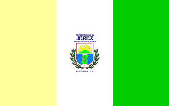
The flag and modified municipal logotype of Jerez is prescribed by Decree No.
20, adopted on 2 June 2009 by the Municipal Council.
The flag is vertically divided yellow-white-green with the municipal logotype in
the middle. Yellow represents the underground resources, the sun, source of
light, as well as sovereignty, harmony and justice. White represents peace.
Green represents hope, life and the natural environment.
Source:
http://munijerez.gob.gt/index.php?option=com_content&view=article&id=120&Itemid=116
- Municipal website
The logotype is made of a shield surmounted by the writing "MUNICIPALIDAD DE /
JEREZ / DEPARTAMENTO DE JUTIAPA". The shield is a regular polygon of rectangular
shape, with a circular base, charged with sun rays, representing a new future,
above a volcano, representing the maximum expression of the municipality.
In the lower part of the shield is the national flag charged in the middle with
a map of the municipality inscribing a maize plant, representing agriculture.
The shield is surrounded by two coffee branches. Beneath the branches is the
writing "GUATEMALA - C.A.".
Source:
http://munijerez.gob.gt/index.php?option=com_content&view=article&id=123&Itemid=118
- Municipal website
Photos:
http://munijerez.gob.gt/index.php?option=com_content&view=article&id=49&Itemid=64
http://munijerez.gob.gt/index.php?option=com_content&view=article&id=120&Itemid=116
Ivan Sache, 10 May 2015