
This page is part of © FOTW Flags Of The World website
Anna Paulowna (The Netherlands)
Noord-Holland province
Last modified: 2018-12-15 by rob raeside
Keywords: anna paulowna |
Links: FOTW homepage |
search |
disclaimer and copyright |
write us |
mirrors
 Shipmate Flagchart : http://www.flagchart.net
never officially adopted
See also:
Anna Paulowna municipality
14.000 inhabitants, 8000 hectares, with the villages of Anna Paulowna,
Breezand, Wieringerwaard, Nieuwesluis and Van Ewijcksluis. This municipality
is in northern Noordholland, between Den Helder and Wieringen and consists
of a polder created in 1845-46, named after the daughter of Czar Paul I
of Russia, Anna Paulowna (1795-1865), married to King Willem II of the
Netherlands. It became an independent municipality in 1870. The first settlers
came from Gelderland; in 1912 it appeared that the soil was good for growing
bulbs, after which people from the Westland (Zuidholland) settled here.
Bee-keepers and potato-growers joined the fun. In 1990 part of the former
municipality of Barsingerhorn was added to Anna Paulowna. Wieringerwaard
was an independent municipality till 1970, when in merged with Barsingerhorn.
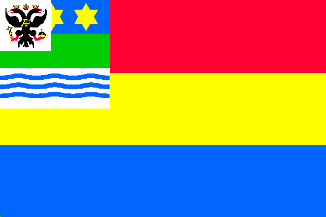
Flagdescription: three equally high stripes of red, yellow and blue
with a canton charged with the municipal arms.
Never officially adopted; design: unknown.
Jarig Bakker, 21 June 2001
Anna Paulowna Coat of Arms
![[Anna Paulowna Coat of Arms]](../images/n/nl-nh)ap.jpg) image from the Anna Paulowna municipal
website.
image from the Anna Paulowna municipal
website.
Granted 24 May 1872
The eagle reminds of Grandduchess Anna Paulowna, daughter of Czar Paul
I of Russia; she married King Willem II, and this municipality was named
after her. The green central part suggests land gained from the sea by
"inpodering"; the water is symbolized by the wavy base, while the chief
represents the starry sky.