
This page is part of © FOTW Flags Of The World website
De Marne (The Netherlands)
Groningen province
Last modified: 2018-12-15 by rob raeside
Keywords: de marne |
Links: FOTW homepage |
search |
disclaimer and copyright |
write us |
mirrors
 Gerard van der Vaart - Shipmate : http://www.flagchart.net
adopted 26 Feb 1991
Other De Marne pages:
See also:
De Marne municipality
Number of inhabitants (1 Jan 2003): 11.180; area: 167,35 km². Settlements:
Leens (seat), Broek, Eenrum, Hornhuizen,
Houwerzijl, Kleine Huisjes, Kloosterburen, Kruisweg, Lauwersoog, Mensingeweer,
Molenrij, Niekerk, Pieterburen, Schouwerzijl, Ulrum,
Vierhuizen, Warfhuizen, Wehe-den Hoorn, Westernieland, Zoutkamp, Zuurdijk
De Marne is a new municipality in northwest Groningen, consisting of
the old municipalities of Ulrum, Leens, Kloosterburen and Eenrum
(since 1 Jan 1990; the municipality was first named Ulrum; on 1 Jan 1992
it was renamed De Marne). It is an agricultural area with the old harbor
of Zoutkamp on the spot where the canalized river 'Reitdiep' streamed into
the Lauwerszee; and of course with the creche for seals in Pieterburen.
Info from <http://www.bng.nl/ngw/m/demarne.htm>:
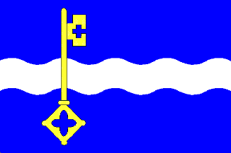
This area was formerly an island in the Hunze river. Named 'De Marne'
it was a division of the region Hunsingo. De Marne enjoyed legal freedom
as the German emperor wasn't able to exert his power there. It had a seal
since 1375 showing St. Peter with a key with a head in the form of a cross.
The seat of justice was in the church, devoted to St. Peter in Leens.
This region is a kind of mirror of the Friesland municipality of
Dongeradeel
and it can't be an accident that both have blue fields
halved by white (wavy) bars. Of the former municipalities Sierksma
(Nederlands Vlaggenboek, 1962) [sie62}
has drawn only the flag of Eenrum.
Jarig Bakker, 7 November 1999
De Marne Coat of Arms
![[De Marne Coat of Arms]](../images/n/nl-gr)dm.jpg) image from the De Marne municipal website.
image from the De Marne municipal website.
Granted 28 Aug 1990.