
Last modified: 2021-08-25 by rob raeside
Keywords: guatemala | chiquimula |
Links: FOTW homepage |
search |
disclaimer and copyright |
write us |
mirrors
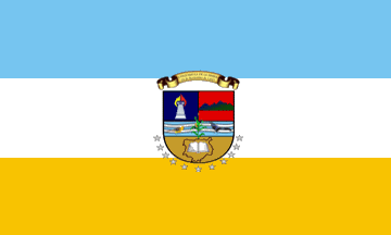 image by Fred Drews, 12 July 2014
See Also:
Municipalities:
Other Sites:
The department of Chiquimula (370,891 inhabitants in 2014; 237,600
ha),
nicknamed the Pearl of the East, is located in eastern Guatemala,
bordering
El Salvador and Honduras.
Ivan Sache, 16 May 2017
The flag, inaugurated on 11 September 2012, was designed by Carlos Humberto
Guerra Pinto, member of the municipality of Ipala, winner of a public contest
organized by the cable TV program "Chiquimula De Visi¾n".
Ivan Sache,
16 May 2017
cq.gif) image by Fred Drews, 12 July 2014
image by Fred Drews, 12 July 2014
The coat of arms is made of a Spanish shield.
The column is a symbol of
arts.
The flame is a symbol of Chiquimula, as a source of enlightenment.
The mountain alludes to the title of the town, Chiquimula de la Sierra.
The
rivers represent the hydrological resources of the department.
The two birds
recall the etymology of Chiquimula, meaning "bird land".
Or recalls the
mining resources, traditions and culture.
The 11 white stars represent the 11
municipalities forming the department. Accordingly, Chiquimula is "the first
department to have a flag representing all its municipalities".
Source:
http://www.michiquimula.com/noticias-es.php?noticia=280 - Mi Chiquimula, 11
September 2012
Ivan Sache, 16 May 2017