
Last modified: 2021-08-26 by  klaus-michael schneider
Keywords: pasteza | mera |
Links: FOTW homepage |
search |
disclaimer and copyright |
write us |
mirrors
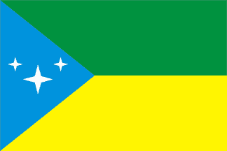 image by Jens Pattke and Falko Schmidt, 5 July
2007
image by Jens Pattke and Falko Schmidt, 5 July
2007
See also:
Mera canton (60,110 ha) is located in the center of Pastaza province. The
canton was established by Decree No. 20, adopted on 10 April 1967 by the
Constituent Assembly and published the next day in the Ecuadorian official
gazette, No. 103.
https://www.municipiomera.gob.ec/
Canton website
Ivan Sache, 18 September 2018
The flag of Mera canton is composed of two horizontal stripes of equal
dimensions. The upper part is green, representing the exuberant vegetation of
the forests and the crops that are the source of income for the region. The
lower stripe, yellow, represents the mining, plant and animal resources, whose
technically improved exploitation shall be a positive factor for the canton's
progress. At left is a blue triangle, representing the sky and the several
rivers that irrigate the soil. It also represents the spiritual resources of the
inhabitants for the conquest of a better cultural and economical standard. The
triangle is charged with a big and two smaller stars, representing the urban
parish and the the two rural parishes of Shell and Madre Tierra, respectively.
Were new parishes to be established in the future, the number of stars would be
automatically incremented.
https://www.municipiomera.gob.ec/simbolos.html
Canton website
Ivan Sache, 18 September 2018