
Last modified: 2013-02-02 by ian macdonald
Keywords: sao paulo | redenção da serra |
Links: FOTW homepage |
search |
disclaimer and copyright |
write us |
mirrors
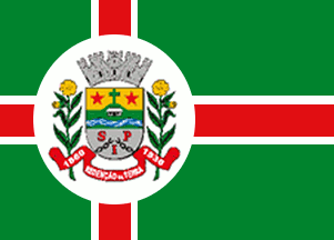 image by Dirk Schönberger,
15 January 2013
image by Dirk Schönberger,
15 January 2013
Based on:
http://pt.wikipedia.org/wiki/Reden%E7%E3o_da_Serra
An off-centred red cross, bordered white, on a green field, with the municipal arms on a white disk on the cross.
Official website at
http://redencaodaserrasp.com
Dirk Schönberger,
15 January 2013
Redenção da Serra was founded in the beginning of the 19th century. The tradition says that Captain Francisco Ferraz de Araújo, his wife Francisca Galvão de França and a group of slaves were sent by the Governor of São Paulo to colonize the Samambaia hinterland. Following a long march, 9 km before reaching river Paraitinga, where the group would settle later, a slave fell to death and the captain ordered to erect a wooden cross to remember him. Years later, a chapel was built near the cross and a small village developed nearby, named Paiolinho. The village is said to have been named from "paiol", "a barn", and "linho", "flax". The building of the village church was completed in 1902. Following the increase of the village during the coffee boom, the district of Paiolinho was established by Provincial Law No. 3 of 24 March 1860, as part of the municipality of Taubaté.
The municipality of Paiolinho was established by Provincial Law No. 33 of 8 May 1877 and inaugurated on 1 December 1977. Downgraded to a district by Law No. 6,448 of 21 May 1934, the municipality was reestablished by Decree No. 7,353 of 5 July 1935 and reinaugurated on 1 January 1936. The municipality was eventually renamed Redenção da Serra ("Redemption in the Mountain) by Decree-Law No. 14,334 of 30 November 1944, recalling that the town was a pioneer in the liberation of slavery, which occurred there on 10 February 1888 (Ponte Alta Charter, signed by the local landlords gathered at the Ponte Alta Estate), before the official abolishment of slavery decreed by Princess Isabel on 13 May 1888. The old town of Redenção da Serra was flooded by the man-made Lake Paraibuna, whose building was initiated in the late 1960s. On 25 August 1975, a big procession led by the diocese's bishop carried a cross from the old town to the place where the new town would be built, on land offered by João Rodrigues de Souza; the event has remained famous as the "Farewell Festival".
The flag of Redenção da Serra, designed by Arcenóe Peixoto de Faria, is green with a red, off-centered cross fimbriated in white. Over the intersection of the cross' arms is placed a white disk charged with the municipal coat of arms. The width of the red stripes is 2 units while each fimbriation has a width of 0.5 unit. The intersection of the cross' arms is placed as 6 units form the hoist. The diameter of the disk is 8 units.
The flag follows the tradition of Portuguese heraldry. The cross recalls the Christian faith of the people. The coat of arms represents the municipal government while the white disk represents the town as the seat of the municipality. The disk is also a symbol of eternity, a circle being a geometric figure without either a beginning or an end. White is a symbol of peace, friendship, work, prosperity, purity, and religious feeling. The arms of the cross represent the municipal power spreading all over the municipal territory. Red is a symbol of dedication, patriotic love, audacity, intrepidity, courage, and valiance. The green quarters represent the rural estates located on the municipal territory.
http://www.redencaopescaesportiva.com.br/index.php?p=ba - Website of
the local fishing club
Ivan Sache, 16 January 2013