
Last modified: 2013-04-27 by ian macdonald
Keywords: sao paulo | gália |
Links: FOTW homepage |
search |
disclaimer and copyright |
write us |
mirrors
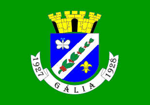 image by Ivan Sache,
1 April 2013
image by Ivan Sache,
1 April 2013
Gália originates in the establishment in 1906 by Bernardo José dos
Santos of the first sugar mill in the region. The village of São José
das Antas was founded in April 1917 by Colonel Galdino and the land
surveyor Francisco Tessitori. The district of Anta was established by
State Law No. 2,176 of 26 December 1926, as part of the municipality
of Duartina. "Companhia Paulista de Estrada de Ferro" inaugurated in
September 1927 the railway station of Gália, named for the ancient
name of France (Gaul).
The municipality of Gália was established by State Law No. 2,229 of 20
December 1927 and inaugurated on 14 April 1928.
http://galia.web807.uni5.net - Municipal website
The flag of Gália is green with the municipal coat of arms in the
middle.
The coat of arms is "Azure a bend sinister argent a branch of coffee
fructed proper cantonned in chief with a butterfly argent in base with
a fleur-de-lis or. The shield surmounted by a mural crown or ports
sable. Beneath the shield a scroll argent inscribed with the
municipality's name surrounded by the years '1927' and '1928' sable".
http://galia.web807.uni5.net/site/?page_id=1247 - Municipal website
Ivan Sache, 1 April 2013