
Last modified: 2020-08-08 by ian macdonald
Keywords: rio grande do sul | pouso novo |
Links: FOTW homepage |
search |
disclaimer and copyright |
write us |
mirrors
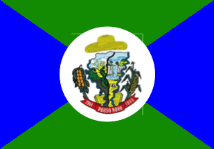 image by Ivan Sache, 2 August 2020
The municipality of Pouso Novo (1,832 inhabitants in 2016; 10,653 ha) is
located 160 km north-west of Porto Alegre.
Pouso Novo was named by Joăo
de Souza Leite, aka Joăo Brasileiro, who settled the place in the beginning of
the 20th century and transformed his house into an inn ("pousada") for tropeiros
traveling between Soledade and Lajeado.
Pouso Novo was elevated to the
5th district of Arroio de Meio by Municipal Law No. 42 promulgated on 6 December
1937. The municipality of Pouso Novo was established by State Law No. 8,581
promulgated on 29 April 1988 and inaugurated on 1 January 1989.
https://www.pousonovo.rs.gov.br/
Municipal website
Ivan Sache,
2 August 2020
The flag of Pouso Novo is prescribed by Municipal Law No. 55 promulgated on 1
May 1990.
Article 1.
The flag of the municipality of Pouso Novo shall
be rectangular, composed of a green and blue panel, with a green triangle in the
upper part and another one in the lower part, a blue triangle on the left part
and another on the right part. Charged in the center, on the triangles'
convergence, with the coat of arms of the municipality.
https://leismunicipais.com.br/a/rs/p/pouso-novo/lei-ordinaria/1990/6/55/lei-ordinaria-n-55-1990-institui-a-bandeira-do-municipio-de-pouso-novo
Leis Municipais database
The coat of arms of Pouso Novo is prescribed
by Municipal Law No. 71 promulgated on 23 August 1990.
Article 1.
A
map of the municipality of Pouso Novo, laterally surrounded by two blue stripes
that represent, left, river Făo, and right, river Forqueta. Vertically crossed
in the center by a dark stripe dotted white in its axis, which represents the
asphalted road, one of the main factors that boosted the municipality's
progress, divided it in the middle. In the map's lower part, left and right,
cattle-breeding, which is the preponderant source of income for Pouso Novo. In
the central part, left and upper right, the hilly and mountainous topography
with replanted and native forests. In the central part, right, a waterfall
representing the natural beauties of tourism interest, which could be developed
in the municipality. In the upper part, left, a golden sun shining on mountains
with rays crossing the clouds, as a symbol of willingness and aspiration to
liberation of a suffering people. In base, an open book appearing like the
source of the map emerging like smoke, as a symbol of community building from
knowledge and proper culture. Beneath the map, a red scroll with white writing
"29 - 04 POUSO NOVO 1988" representing the municipality's date of political
emancipation. The map surrounded left by beans, right by maize and wheat, the
main crops. The shield surmounted by a colonist's straw hat, symbolizing farmers
as the main force of the municipality and stressing that power should emanate
from people.
https://leismunicipais.com.br/a/rs/p/pouso-novo/lei-ordinaria/1990/8/71/lei-ordinaria-n-71-1990-institui-o-brasao-do-municipio-de-pouso-novo-e-da-outras-providencias
Leis Municipais database
Photos
https://www.facebook.com/prefeiturapousonovo/photos/a.388828794873933/725117831245026/?type=3&theater
https://www.facebook.com/prefeiturapousonovo/photos/a.858908864532588/858911804532294/?type=3&theater
https://www.facebook.com/prefeiturapousonovo/photos/a.388828794873933/725117741245035/?type=3&theater
Ivan Sache, 2 August 2020