
Last modified: 2022-03-05 by ian macdonald
Keywords: parana | imbituva |
Links: FOTW homepage |
search |
disclaimer and copyright |
write us |
mirrors
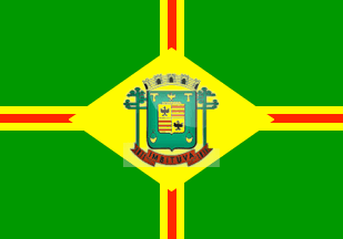 image by Ivan Sache, 3 February 2022
The municipality of Imbituva (28,759 inhabitants in 2010; 75,653 ha) is
located 175 km west of Curitiba. The municipality is composed of the districts
of Imbituva (seat) and Apiaba (originally established as São Miguel do Pinho by
State Law No. 2,757 promulgated on 31 March 1930, renamed to São Miguel by State
Law No. 6,667 promulgated on 31 March 1938, and eventually to Apiaba by State
Decree-Law No. 199 promulgated on 30 December 1943.
Imbituva was
established in 1871 by pioneer and tropeiro Antonio Lourenço, from Faxina, in
the area then known as Cupim. The parish of Santo Antônio de Imbituva was
erected by Provincial Law No. 441 promulgated on 21 February 1876, to be
elevated a town (municipality) by Provincial Law No. 651 promulgated on 26 March
1881, separating from Ponta Grossa. The new municipality, seated in Campo de
Cupim, was inaugurated on 14 June 1882.
The name of the municipality was
shortened to Imbituva by State Law No. 2,645 promulgated on 10 April 1929.
Imbituva is named for the local river, from a Tupi-Guarani word meaning "a place
planted with several imbé [Philodendron imbe (Schott ex Kunth)]".
http://imbituva.pr.gov.br/
Municipal website
The flag of Imbituva is green, quartered by a
yellow-red-yellow cross superimposed with a yellow lozenge inscribing the
municipal coat of arms.
Photos
https://www.facebook.com/PrefeituradeImbituva/photos/1481848715290166
https://www.facebook.com/PrefeituradeImbituva/photos/1141782089296832
Ivan Sache, 3 February 2022