
This page is part of © FOTW Flags Of The World website
Oostflakkee (The Netherlands)
Zuid-Holland province
Last modified: 2018-12-15 by rob raeside
Keywords: oostflakkee |
Links: FOTW homepage |
search |
disclaimer and copyright |
write us |
mirrors
 Shipmate Flagchart : http://www.flagchart.net
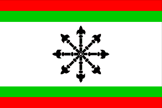
adopted 19 Aug 1974.
See also:
Oostflakkee municipality
Number of inhabitants (1 Jan 2003): 10.166; area: 107,04 km². Settlements:
Oude-Tonge (seat), Achthuizen, De Langstraat, Den Bommel, Ooltgensplaat,
Zuidzijde.
In 1966 Oostflakkee (the easternmost part of the island of Goeree-Overflakkee)
was formed by the merger of the former municipalities of Oude-Tonge, Ooltgensplaat,
and Den Bommel.
The black item on the flag is an escarbuncle.
Oostflakkee Coat of Arms
of.gif) International Civic Arms : http://www.ngw.nl/
International Civic Arms : http://www.ngw.nl/
Granted 6 Jun 1966.
Oude-Tonge [former municipality]
 Shipmate Flagchart : http://www.flagchart.net
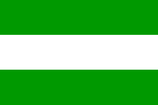
Flagdescription: Three equally wide horizontal stripes of green and
white.
This flag is not official, but is used as such by the municipal council
and the citizens. The image is the same as the municipal arms.
Oude-Tonge Coat of Arms
See International Civic Arms : http://www.ngw.nl/