
Last modified: 2024-01-20 by rob raeside
Keywords: berg en dal |
Links: FOTW homepage |
search |
disclaimer and copyright |
write us |
mirrors
 Wikipedia:
https://nl.wikipedia.org/wiki/Groesbeek
Wikipedia:
https://nl.wikipedia.org/wiki/Groesbeek
adopted 21 May 1964
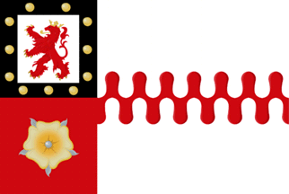
Berg en Dal is a new municipality in Gelderland, created on January 1st 2015,
by merging the municipalities of Groesbeek, Millingen aan de Rijn, and Ubbergen.
The new municipal flag was adopted on 22.09.2016.
Valentin Poposki,
9 December 2023
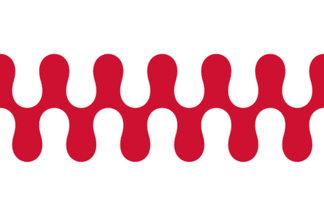 image by Valentin Poposki, 9 December 2023
adopted 21 May 1964
The old flag (adopted 1962) had horizontally on top and bottom small
BY and YB stripes, to accentuate the link with the province Gelderland.
Apparently this has now been established and the small stripes have
gone. The nebuly bar is derived from the municipal Coat of Arms.
Jarig Bakker, 26 September 1999
 Shipmate Flagchart : http://www.flagchart.net
In use 1962-1964
![[Groesbeek Coat of Arms]](../images/n/nl-ge)gb.gif) image from the Groesbeek municipal website.
image from the Groesbeek municipal website.
Granted 11 December 1937
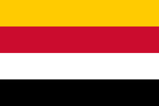 image by Valentin Poposki, 9 December 2023
Number of inhabitants (1 January 2003): 5.910; area: 10,35 km². Settlements:
Millingen aan de Rijn (seat).
Millingen is c. 30 km east of Nijmegen. Here the Rhine is split into
the Waal en the Rhine (here called 'Pannerdens kanaal'). Its name might
be derived from 'milliarium' (milepole) on the Roman military road.
The flag is another fine example of Dutch 'banenvlaggen' (horizontally
striped flags), derived from the colors of the 4 quarters of the Coat of Arms, reminding
of 4 important families of the region.
Jarig Bakker, 6 October 1999
![[Millingen aan de Rijn Coat of Arms]](../images/n/nl-ge)mr.gif) image from the municipal site.
image from the municipal site.
Granted 12 November 1947.
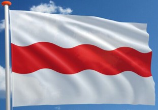 image located by Valentin Poposki, 9 December 2023
From https://www.mastenenvlaggen.nl/product/dorpsvlag-persingen:
The flag of Persingen has been in use in its current form since 2022 and was designed by Mr. Maas. The design is very similar to the flag of Gaastmeer. The Persinger flag is white in color and has a horizontal red wavy stripe.
The design is traced back to one of the family coats of arms of the Lords of Persingen, namely that of Mr Tieleman van Groesbeek from the 14th century. The meaning of the white and red color is not known. That is why it has its own symbolism. For example, the undulating track represents the Waal river and the Meertje. The Meertje is a watercourse that flows into the Waal. Both waters could be quite hostile towards Persingen, due to the risk of flooding. The red color refers to the battle against the water and also to the battle that took place between the Dukes of Gelre and Cleves to claim this area.
More information: https://www.gelderlander.nl/
Valentin Poposki, 9 December 2023
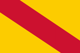 image by Valentin Poposki, 9 December 2023
adopted 27 December 1957
Population (1 Jan 2003): 9.270; area: 38,81 km². Settlements: Beek
(seat) 3.433; Ubbergen 521; Ooij 2.267; Leuth 1.768; Kekerdom 608; Berg
en Dal 414; Persingen 100 and Erlecom 159.
Ubbergen is east of Nijmegen, virtually part of it. In Roman times
there was 'Oppidum Batavorum', a small fort. There were 8 brick factories
here.
The flag was adopted 27 December 1957; colors derived from the Coat of Arms (a yellow
rose on a red shield)
Jarig Bakker, 14 October 1999