
Last modified: 2021-12-24 by rob raeside
Keywords: san juan | provincia de san juan | jáchal | san josé de jáchal | angaco | caucete | chimbas | iglesia | pocito | rawson | valle fértil |
Links: FOTW homepage |
search |
disclaimer and copyright |
write us |
mirrors
The Province of San Juan is administratively divided in 19 departments. This province it is a special case between Argentine provinces, because inside each department there is one municipality. There are three kinds of municipalicities according their size: Primera (First Class) for the bigger ones, and Segunda (Second Class) and Tercera (Third Class) for the smaller ones.
Francisco Gregoric, 20 Apr 2008
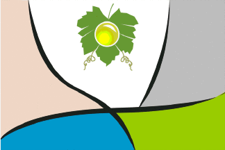 image sent by Ivan Sache, 21 May 2017
The municipality of Albardón (20,413 inhabitants in 2001; 945 sq. km) is located in the north of the San Juan Province, 15 km north of the provincial capital. Albardón is located in the valley of river San Juan. Protected by the Pie de Palo and Villicum ranges, the region enjoys a warm, dry climate; Albardón is nicknamed the "Land of Sun and Muscat grape". Travertine marble and dolomite are extracted from the foot of the Villicum range.
Albardón was originally settled by the Huerpes, who grew maize, squash and watermelons. The Spanish colonists called Angaco Valley an area including the today's municipalities of Albardón, Angaco and San Martín. Albardón was the place of the Las Tapais watchtower. The first urban nucleus in the valley was established in 24 January 1866 as Villa General San Martín. The municipality of Albardón was established on 9 December 1869 as one of the 18 "departments" forming the San Juan Province.
In "Diario de Cuyo", 20 January 2011, Diego Castillo reports the adoption of the flag of Albardón.
The flag was adopted in a public contest; the Commission for the Establishment of the Flag selected three contenders among the
submitted proposals. The flag was expected to be officially unveiled on 26 January and hoisted for the first time during the municipal festival, scheduled to 28-30 January.
The flag is described as follows:
"A group of gray lines representing the streets and roads, which divide the flag into colored geographic areas. This kind of aerial map is ensigned, mostly, with a grapevine leaf and a Muscat grape grain."
Ivan Sache 26 May 2012
The Department of Angaco (7,570 inhabitants; 1,865 sq. km), founded on
16 March 1816, is located in the central western part of the Province
of San Juan. In 1869, Angaco was split into Angaco Sur and Angaco
Norte; in 1942, the two departments were renamed San Martín and
Angaco, respectively.
The flag of the department, as shown in "Diario de Cuyo", 3 November
2008, is yellow with two celeste blue and white diagonal stripes in
the upper left corner, the white stripe extending up to the lower left
corner. The yellow panel is charged with two animals and an Indian.
Ivan Sache 04 Nov 2008
The flag of Angaco is prescribed by Decree No. 165 of 13 March 2001.
The flag is rectangular, with three diagonal stripes of unequal
height. celeste blue, white and yellow. From the upper left to the
lower right corner of the flag, the celeste blue and white stripes
cover c. one third of the flag, in a non proportional manner, while
the yellow stripe covers the remaining part of the flag.
The flag is smaller in size than the national flag, 1.35 m x 0.85 m,
made of polyester for regular hoisting and of embroidered silk for
ceremonial use. The flag shall represent the municipality in all
official events, which cannot be held without it.
Celeste blue represents the diaphanous sky over Angaco, which allows
people to live from the products of the soil.
Yellow represents the Papal banner, as a tribute to the Christian
faith of the people, and as the symbol of God's protection.
The central right part of the flag pictures two petroglyphs
representing the native tribes that once lived in Angaco.
"Diario de Cuyo", 19 May 2005, gives the name of the designer of the
flag, Máximo Caballero, and of those who embroidered it in 2002, Inés
and Leonor Bustos.
The Angaco petroglyphs are found in canyons located in the Pie de Palo
mountain. They have been analyzed in detail by the local archeologists
Adriana del Valle Varela and María Gabriela Riveros (Arte Rupestre de
San Juan: Petroglifos de Angaco (Obra Abierta en el Espacio y el
Tiempo), Chungará, 2004, 36 S 2, 663-671)
Ivan Sache 28 May 2012
 image by Ivan Sache, 04 Nov 2008
The Department of Caucete (33,609 inhabitants in 2001; 7,502 sq. km)
is located in the east of the Province of San Juan. It includes the
nine Districts of Bermejo, Caucete (capital), El Rincón, Marayes, Las
Talas, Los Médanos, Pie de Palo, Vallecito and Valle de Independencia.
In "Diario de Cuyo", 3 November 2008, Daina Kaziura reports the
adoption of the flag and arms of Caucete, adding that Chimbas, Jáchal
and Pocito also have both a flag and a coat of arms. Rawson, Angaco,
Valle Fértil and Iglesia also have a flag, but no coat of arms. Images
of the flag are shown, but the flag of Caucete is the only one
described in detail.
The flag design was selected among eight entries in a competition
organized by the Secretary of the Municipal Government of Caucete. The
winning design was realized by Diego Albarracín, Sofía Gil, Aída
López, Rosa Pascual and Gladis Vives.
The flag shows three diagonal stripes celeste blue-white-celeste blue,
as the national flag of Argentina; the diagonal pattern recalls
Diagonal Sarmiento, the main street of the department. The flag is
charged in the middle with a map of the department in pale yellow with
an ochre border, itself charged with the Pie de Palo mountain, a grape
(symbolizing the main local industry), and a yellow rising sun with
nine rays symbolizing the nine districts of the departments.
After the image shown by "Diario de Cuyo"; on this source, the sides of the diagonal "streets" are not parallel and the map is not centered.
Ivan Sache, 04 Nov 2008
The Department of Chimbas (73,829 inhabitants in 2001; 62 sq. km),
created on 11 December 1913, is located in the center of the Province
of San Juan. It includes the two Districts of Chimbas and El Mogote
and is part of the Greater San Juan.
The flag of the department, as shown in "Diario de Cuyo", 3 November
2008, is horizontally divided celeste blue-white-celeste blue, like
the national flag o Argentina, with several charges, including the
muncipal coat of arms placed diagonally near the lower left corner and
a big yellow sun placed in the upper right corner.
Ivan Sache 04 Nov 2008
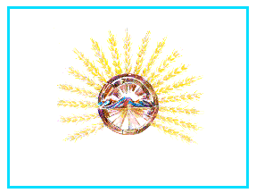 image by Olivier Touzeau, 30 Dec 2001
At http://www.jachal.com/Principal.html,
you may see the flag of the department of Jáchal,
in San Juan province, Argentina.
Olivier Touzeau, 13 Nov 2001
The Department of Iglesia (6,737 inhabitants; 19,801 sq. km), founded
on 25 November 1753, is the northernmost department of the Province of
San Juan.
The flag of the department, as shown in "Diario de Cuyo", 3 November
2008,is horizontally divided green-white-blue with a yellow, 7-rays
rising sun in the white stripe.
Ivan Sache, 04 Nov 2008
The Department of Pocito (40,969 inhabitants in 2001; 515 sq. km),
crated on 9 December 1869, is located in the center of the Province of
San Juan, south of the town of San Juan.
The flag of the department, as shown in "Diario de Cuyo", 3 November
2008, is horizontally divided celeste blue-white-celeste blue with the
municipal coat of arms, placed half on the upper blue stripe and half
on the central white stripe, and a handshake placed in the lower blue
stripe.
The coat of arms of Pocito can be seen on the municipal website. Its
main element are the local replica of the Statue of Liberty and, most
probably the Marian Indian woman featured in a local legend.
Ivan Sache, 04 Nov 2008
The Department of Rawson (107,740 inhabitants in 2001; 300 sq. km),
created on 4 September 1942, is located in the center of the Province
of San Juan, south of the town of San Juan. It is made of the three
Districts of Villa Krause (capital), El Medanito and Villa Bolańos.
The department is named after Dr. Guillermo Rawson (1821-1890), a
doctor and politician born in San Juan.
The flag of the department, as shown in "Diario de Cuyo", 3 November
2008, is horizontally divided white-blue. The white stripe is charged
with a cogwheel-sun emblem, while the blue stripe is charged with two
open hands (?).
Ivan Sache, 04 Nov 2008
The Department of Valle Fértil (6,864 inhabitants in 2001; 6,419 sq.
km) is located in the north eastern part of the Province of San Juan.
It is famous for the Natural Park of Ischigualasto and, especially,
the Moon Valley.
The flag of Valle Fértil is vertically divided light blue-white-light
blue (1:2:1). In the middle of the flag is a representation of "El
Hongo" (The Mushroom). "El Hongo", the emblem of the Moon Valley, is
a mushroom-shaped rock. The Moon Valley is bristled with such rocks
with odd shapes; they are made of volcanic material once embedded in
softer sedimentary layers subsequently removed by wind and waters.
On 29 November 2000, the Ischigualasto Provincial Park, famous among
paleontologists for its late Triassic deposits and the fossils they
contain, was registered as a World Heritage Site by UNESCO. The
municipality of Valle Fértil decided to adopt a flag to be hoisted in
the park, which is located on the municipal territory.
At the end of 2003, the municipality commissioned the vexillologist
Eduardo Caballero, who drafted three flag proposals. The students of
the local School of the Air Force and of the Agrotechnical School
selected a design, which was accepted without any official validation.
The flag was hoisted, unofficially, on 20 September 2004, during a
demonstration of the inhabitants of Valle Fértil against the
Provincial government. Caballero, however, insisted that the flag
could not be used in official ceremonies without approval and blessing.
The Municipal Council eventually issued a Decree approving the flag,
which was unveiled in Usno on 12 October 2006, during the celebration
of the Day of the Race.
Ivan Sache, 04 Nov 2008 & 12 Nov 2011